Lake Pedder, Tasmania
a walk in World Heritage Wilderness

STORY BY PETER SALHANI | Photography Cody Mccraken, Andy Szollosi, Alec Balcombe
In Tasmania’s World Heritage Southwest Wilderness, Lake Pedder bears the scar of a bitter conservation war – lost but not forgotten. Sparkkle editor Peter Salhani takes the Wild Pedder Trek through ancient alpine ranges, river gorges and rainforest.
One hundred and fifty kilometres northwest of Hobart, Lake Pedder lies in wait. The tea-black waters of this infamous drowned lake are central to Tasmania’s Southwest National Park. Guiding our four-day journey are local lad Lou Balcombe, a second-generation hydraulics engineer, whose father had worked on the Gordon Dam, and Andy (András) Szollosi, a Budapest-born wilderness photographer, who moved to Melbourne at age 14, then Tasmania in his 20s, to walk its peaks and valleys.
They are legends in the Tasmanian outdoors community, balancing their trekking and guiding time with working on landcare cleanups and protesting against habitat destruction. They collect us in Hobart and head an hour northwest, to the hops district of Bushy Park, for breakfast and a briefing.

Photo: Alec Balcombe.
“Few Australian national parks have such vegetal diversity.”
On day one, we head for Mount Field National Park to walk the 15-kilometre Twisted Lakes/Tarn Shelf Track: a ‘tarn’ is a lake at the highest point of a glacial valley. As we climb, swamp gums, tree ferns and mop-top pandani give way to myrtle and wildflower thickets, then above the Tarn Shelf, snow gums! Few Australian national parks have such vegetal diversity. Up on the icy Tarn Shelf, myrtle and pencil pines are bonsai’d by the icy winds, amid a carpet of wildflowers. “At 1,000 metres, wind and cold are the gardeners,” says Szollosi.

The Fagus, Nothofagus gunnii on the Tarn Shelf.
It’s only mid-April, but the wind is already icy and the ‘Fagus’ are starting to turn. Nothofagus gunnii is Australia’s only cold-climate deciduous tree: a small variety of beech, it reaches no more than 5 metres high, and mostly not more than two. It grows nowhere else in the world but here, and we are catching it in the act! All around Lake Newdegate, its tiny crimped leaves are turning amber, gold and russet as autumn bites. By mid-May it will all be over. The spectacular ‘turning of the Fagus’ is celebrated with a festival of local arts and wilderness walks. It’s Tasmania’s version of the Japanese Sakura (cherry blossom season).

Alpine meadow up on the Tarn Shelf. Photo: Cody McCracken
“BONSAI’D BY THE ICY WINDS are myrtle, pencil pines and a carpet of wildflowers.”
The next morning our first stop is Gordon Dam for a look at the longest public abseiling runs in the world, then onto the Sprent Basin, where we begin a 16-kilometre kayak crossing of Lake Pedder. Out in the Serpentine Reach, we find ourselves in murky waters, a perceptible shift in energy. Below us is the old Serpentine River bed. It once snaked its way across the valley floor, draining the original (much smaller) Lake Pedder into (first) the Gordon River, then Macquarie Harbour, then out to the Southern Ocean.
The first European to make that voyage was a Lithuanian refugee named Olegas Truchanas, who did it alone in his handmade canoe. A beguiled Truchanas had settled in Tasmania after World War II, making a lifetime of lengthy solo trips into this wilderness. After each trip, he would share his findings and his photography to packed public lectures around Tasmania.

The salt white sands and tea-black waters of Lake Pedder. Photo: Cody McCracken
“BIRDCALLS AND WATERFALLS DRIFT IN AND OUT OF EARSHOT.”
Through the Reach, bounded by Precambrian quartzite peaks (the Frankland and Sentinel ranges), and jurassic dolerite (Mount Wedge and Mount Anne), birdcalls and waterfalls drift in and out of earshot. We stop for lunch at Wilmot Island’s white quartz beach, where a few of us strip off to brave the water, a bracing 12 degrees at best.
Having kayaked lazily under the clouds all of day three, on day four we climb up into them. This will prove the biggest challenge of the trip – an eight-hour return circuit on Mt Eliza. From Condominium Creek we head east over a narrow boardwalk through buttongrass meadows before our ascent begins abruptly. We climb 1,000 metres up a steep track, mostly defined by steps, with our guide Andy pointing out the tiny holes where freshwater crayfish hide. Looking back, a vast panorama unfurls.
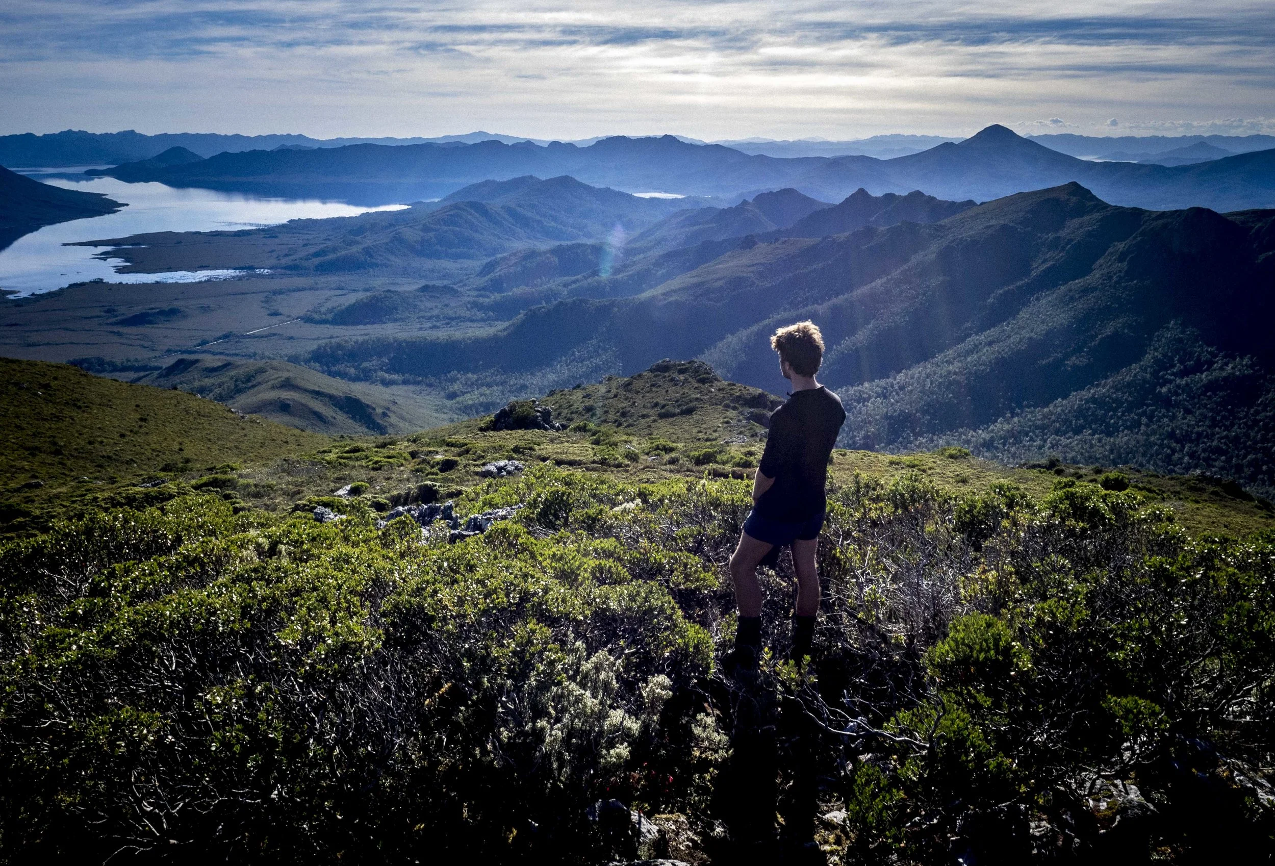
A mountain view back to Lake Pedder. Photo: Andy Szollosi
On a spur just below the treeline, we lunch at Eliza Plateau, near High Camp Hut, a bushwalker refuge. At this altitude, Tasmania’s smallest eucalypt, the varnished gum, is little more than a shrub. We rest in the afternoon sun, while bees are at work on native plum and pepperberry bushes, and thorny bauera. Circling above, is an endangered wedge-tailed eagle, up-drafting near Eliza’s peak.
Day four takes us out of the clouds and into the Upper Florentine Regional Reserve, home to some of the tallest trees on earth, Eucalyptus regnans –– the swamp gum We fill our water bottles from Churchill Creek then take the Adamsfield track (an old mining road), into a forest of sassafras, leatherwoods and giant tree ferns, thriving in the cool lower canopy. In a clearing we reach Churchill Hut, where trapper and logger Elias Churchill impounded the last Tasmanian tiger in 1933. Thylacine ‘sightings’ still abound today.

Tiny Pixie’s Parasol fungi feeding on fallen giants in Tasmania’s Upper Florentine Valley. Photo: Andy Szollosi
Racing for light in the clearings around fallen giants are saplings of celery-top and tea-tree, surrounded by apple berry, flax-lily, and saw-toothed wheatgrass. On the forest floor moss, lichen and fungi are busy composting every fallen leaf and limb back into life-giving humus. Amid the patchwork of deep greens and black earth come flashes of coloured fungi – milky whites, tangerine and the brilliant cyan Mycena interrupta (Pixie’s parasol) no bigger than a thumbnail. “The more variety of fungi you find, the healthier the forest,” assures Balcombe.

A towering, ancient Swamp gum (E. regnans) in Tasmania’s Upper Florentine. Photo: Cody McCracken.
We reach a stand of old swamp gum, with trunks three metres in diameter or more. Their bark is draped in moss and ferns, their knuckles protruding over hollows at the base, like awnings. One of these titans has a crown of spires so far above the canopy they can’t be counted. We sit in silence for a moment with these ancient brothers, who predate the British invasion by centuries.
After years of campaigning against its old-growth logging, the Upper Florentine was inscribed into the Tasmanian Wilderness World Heritage Area in 2013. In 2011, activist Miranda Gibson had climbed 60 metres up into the Observer Tree (a 400-year-old swamp gum), where she survived on a suspended wooden platform, for 449 days, aided by volunteers on the ground. Today, the nearby Styx Valley is still under threat from old-growth logging.

A view across Lake Pedder to the Coronets and Sentinel Ranges. Photo: Cody McCracken
Breathtaking as it is, Pedder is an altered landscape. The original lake was drowned in the early 1970s when the Hydro Electric Commission dammed the Serpentine and Huon rivers to make cheap electricity for an aluminium smelter. Olegas Truchanas campaigned against it for years, along with countless others locally and internationally, including artist Max Angus and Brenda Hean, who vanished without a trace in 1972. Nearly 50 years later, many believe that the lake, with its dazzling 3-kilometre beach of pink quartz sand, and the Serpentine River, are still intact, waiting to be awoken.
“BREATHTAKING AS IT IS, PEDDER IS AN ALTERED LANDSCAPE. ”
Pedder’s damming sparked an outrage that led to the birth of The Australian Greens, and the defeat of the proposed Gordon-below-Franklin Dam. In 1986, Greens founder and former senator, Bob Brown, published Lake Pedder, with images by Olegas Truchanas, David Neilson and others who tried to save it. Although angry about the damming, Brown wrote optimistically: “Lake Pedder lies beneath the tide of insensitivity which still curses human affairs... but beyond these times, a wiser and kinder age beckons us into the future.”
“WE TAKE ONLY PHOTOGRAPHS AND we LEAVE ONLY FOOTPRINTS.”
Whether or not the damming is undone, returning Lake Pedder to its natural state, the Tasmanian outdoors community, and every other collective that fights for nature’s inherent rights to exist, is vital to humanity’s “wiser, kinder future” that Bob Brown refers to. Lou Balcombe’s first instruction to us on day one could well be a mantra for our time: “Whenever we enter a wild place, one rule applies: we take only photographs and we leave only footprints.”
